E-navigation
The concept of e-navigation was brought to the attention of the Organization for the first time at the eighty‑first session of the Maritime Safety Committee (MSC) in 2006. Since then, MSC has been leading and coordinating the work on the development of e-navigation strategy with active participation from relevant IMO Sub‑Committees (COMSAR, NAV1, STW2 and FAL), Member States, international organizations (e.g. IALA and IHO) and industry representatives.
What is e-navigation?
The e-navigation concept is governed by IMO as the organization responsible for establishing mandatory standards for enhancing the safety of life at sea, maritime security and protection of the marine environment, as well as having global remit for shipping.
The Organization defines e-navigation as "the harmonized collection, integration, exchange, presentation and analysis of marine information on board and ashore by electronic means to enhance berth to berth navigation and related services for safety and security at sea and protection of the marine environment."
E-navigation is intended to meet present and future user needs of shipping through harmonization of marine navigation systems and supporting shore services. It is expected to provide digital information and infrastructure for the benefit of maritime safety, security and protection of the marine environment, reducing the administrative burden and increasing the efficiency of maritime trade and transport.
Understanding e-navigation further
E-navigation is not a static concept, its development will be ongoing as user requirements evolve and as technology develops.
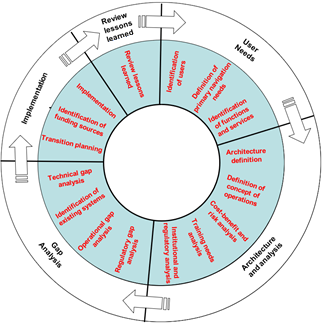
The Organization developed the e-navigation Strategy Implementation Plan (SIP), introducing a vision for e‑navigation and providing the industry with harmonized information in order to start designing products and services to meet the e‑navigation solutions.
The main objective of the e-navigation SIP is to implement the following five e-navigation solutions:
- S1: improved, harmonized and user-friendly bridge design;
- S2: means for standardized and automated reporting;
- S3: improved reliability, resilience and integrity of bridge equipment and navigation information;
- S4: integration and presentation of available information in graphical displays received via communication equipment; and
- S5: improved communication of VTS Service Portfolio (not limited to VTS stations).
As user needs evolve and new technology is introduced, other e-navigation solutions may be incorporated into the e-navigation SIP, as appropriate.
The e-navigation SIP identified the actions and tasks necessary to progress the development and implementation of the five e-navigation solutions and contained also a proposed list of maritime services to be transitioned from conventional transmission methods to contemporary digital technologies by means of provision and exchange of the relevant information and data in a harmonized and unified format.
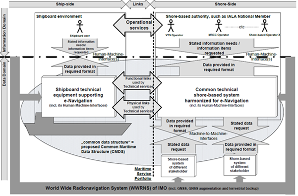
The overarching architecture of the e-navigation concept is illustrated in this figure:
MSC keeps the e-navigation SIP under continuous review and regularly updates it based on the progress made, taking into account the evolution of user needs and the lessons learned from each phase of the implementation.
Further information
-
Strategy for the development and implementation of e-navigation (MSC 85/26/Add.1, annex 20)
-
Framework for the implementation process for the e-navigation strategy (MSC 85/26/Add.1, annex 21)
-
Guidance on the definition and harmonization of the format and structure of maritime services in the context of e-navigation (MSC.467(101))
-
Guidelines on harmonization of testbed reporting (MSC.1/Circ.1494)
-
Guideline on software quality assurance and human-centred design for e-navigation (MSC.1/Circ.1512)
-
E-navigation strategy implementation plan – Update 1 (MSC.1/Circ.1595)
-
Initial descriptions of maritime services in the context of e-navigation (MSC.1/Circ.1610)